
The Galatians: Celts in the Land of Anatolia
When the apostle Paul addressed his letter to the "churches of Galatia" (Galatians 1:2), approximately between the years 48 and 55 A.D., he was writing to Christian communities scattered across a vast region of interior Anatolia (modern-day Turkey). But who, after all, were the Galatians and how did a Celtic people end up so far from their ancestral homeland in Europe?
The history of the Galatians in Anatolia begins with a great migration. Around 278 B.C., approximately 20,000 Gauls—Celtic peoples originating from the region that today comprises France and adjacent territories—crossed the continent and settled in the mountainous region of central Anatolia. This migration was not isolated; it was part of a larger wave of Celtic expansion that swept across Europe during the Hellenistic period, carrying Celtic groups from the British Isles to the Near East.
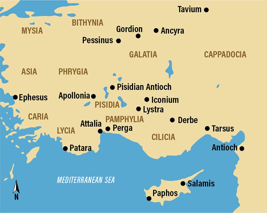
The Galatians established themselves in a region that came to bear their name: Galatia. The principal city of this Galatian territory was Ancyra (modern Ankara, the current capital of Turkey). Despite being numerically reduced compared to the indigenous Anatolian population, the Galatians exerted significant cultural and political influence, maintaining their Celtic language and traditions for centuries.
From Independent Kingdoms to Roman Province
For more than two centuries, Galatia remained a kingdom, frequently functioning as a client state of Hellenistic and later Roman powers. The region was governed by a tribal aristocracy, with the Galatians organized into three major tribes: the Trocmi, the Toleistobogii, and the Tectosages. This decentralized political structure reflected the Celtic roots of the people, who historically resisted the centralization of power.
In 25 B.C., the situation changed dramatically. The Galatian territory was absorbed by the Roman Republic and transformed into a formal province. More significantly, the Roman province of Galatia was expanded to include regions to the south, incorporating the areas of Pisidia, Phrygia, and Lycaonia—territories that were originally not Galatian in population or ethnic tradition, but now became part of the unified Roman administration under this name.
Galatia in the Time of Paul: A Question of Boundaries
The exact size and precise boundaries of the province of Galatia in the first century A.D. constitute a long-standing puzzle for scholars of biblical and archaeological history. The question is not merely academic—it directly affects the understanding of who Paul's audience was when he wrote to the Galatians.
For centuries, scholars divided Galatia into two categories: "North Galatia" (the original geographic region, in central Anatolia, where the Gallic Celts settled) and "South Galatia" (the more southern lands of Pisidia, Phrygia, and Lycaonia that were incorporated when Rome formalized the province).
According to the narrative of the Book of Acts, Paul traveled through this "South Galatia," visiting specific cities such as Antioch of Pisidia, Iconium, Lystra, and Derbe (Acts 13–16). The apostle also visited Perga and Attalia, ports on the Mediterranean coast of the Pamphylia region (Acts 13–14). The persistent question was: did the cities of Pamphylia, particularly Perga, fall within the jurisdiction of Galatia when Paul visited them? And therefore, would their inhabitants be included among the recipients of the letter to the Galatians?
Archaeological Evidence Rewrites History
In recent years, archaeological discoveries have shed new light on this question. Mark Wilson, a researcher at the Asia Minor Research Center in Antalya, Turkey, gathered evidence from multiple sources to reconstruct the true boundaries of the province during the first century A.D. His work was published in the fall of 2020 in the journal Biblical Archaeology Review, under the title "Galatia in Text, Geography, and Archaeology."
Wilson's research identifies three archaeological discoveries that are particularly crucial in altering our understanding of Galatia's territorial extent:
The Stadiasmus Patarensis and the Boundaries of Lycia
An inscription called the Stadiasmus Patarensis was discovered in the city of Patara, in the Lycia region. Dated to 46 A.D., this roadside monument inscription lists the boundaries and adjacent provinces of the region. Crucially, it mentions Pamphylia as a province neighboring but distinct from Lycia, contradicting an earlier theory that Lycia and Pamphylia had been governed as a single Roman province during the apostolic period.
The Latin Inscriptions of Perga
Two even more significant artifacts emerged from excavations at Perga, an important harbor city in Pamphylia. These are two Latin inscriptions dated to the late 40s and early 50s A.D. Both explicitly mention "Galatia and Pamphylia" as a joint administrative unit. One of these inscriptions, dated to the 40s A.D., even names a specific Roman official: Sextus Afranius Burrus, who served as procurator of this unified province.
These discoveries strongly suggest that the Roman administration had consolidated Galatia and Pamphylia under a single province during the time when Paul visited the region. This means that cities like Perga and Attalia, though geographically situated on the Mediterranean coast, were officially part of the Roman "Galatia."
Implications for Paul and His Communities
If the province of Galatia indeed extended from the central Anatolian plateau to the Mediterranean Sea, this implies that the "churches of Galatia" to which Paul addressed himself were not limited only to the communities of the mountainous interior (in cities such as Lystra and Iconium), but potentially also included communities in the Pamphylian coastal cities such as Perga and Attalia.
This geographic expansion of the letter's original scope means that Paul's audience was larger and more geographically dispersed than earlier scholars had supposed. The converts in Pamphylia, many of whom were probably Greeks, Jews of the Diaspora, and other cosmopolitan urban populations of the coast, would have received the same letter as the converts in the more remote mountainous interior communities.
The question of the recipients of the letter to the Galatians also illuminates the nature of early Christianity in Asia Minor. The churches of Galatia appear to have been established through a combination of apostolic journeys directed to specific cities (as recorded in Acts) and possibly through commercial and communication networks that connected coastal cities to interior centers. This model of dispersal reflects the reality of first-century A.D. communications, where harbor cities like Perga served as entry points and distribution centers for religious and commercial messages that later traveled inland.
The Celtic-Anatolian Context in Transformation
It is important to note that, although the Roman province was called "Galatia"—in honor of the Celts who originally settled there—the first-century A.D. population was ethnically far more mixed. Centuries of shared residence, interethnic marriage, and migration meant that Roman Galatia was a cultural melting pot, a contact zone where Greek, Oriental, Semitic, and Celtic influences intertwined.
The Latin inscriptions naming Roman procurators and the documented presence of Roman colonists indicate that Roman administration had left its mark on the territory. Simultaneously, the Galatian language continued to be spoken among some segments of the population, particularly in the interior, where the ancient tribal structure still exerted cultural influence. The historian Jerome Murphy-O'Connor noted that the Galatian language was still spoken in Galatia until the sixth century A.D., testifying to the persistence of Celtic identity even under Roman rule.
The Historical Importance of Understanding Galatia
The work of scholars such as Mark Wilson demonstrates how archaeology and epigraphy (the study of inscriptions) can illuminate fundamental questions about the historical context of New Testament texts. The Latin inscriptions from Perga reveal not only information about Roman administration or political geography—they tell us something about who was reading Paul's letter, in which cities, and how these communities were distributed geographically in a cosmopolitan empire.
Galatia exemplifies the multiethnic and multicultural character of the Roman Mediterranean in the first century A.D. A small group of Gallic Celts, established millennia before, had become absorbed into a larger Roman political-administrative framework while maintaining elements of their original identity. This same territory now housed early Christian communities that Paul considered important enough to write one of his most theologically dense epistles. The overlapping layers—Celtic, Hellenistic, Roman, Semitic, and Christian—in a single geographic territory summarize the complexity of the ancient world.
Notes and References
- Mark Wilson, researcher at the Asia Minor Research Center (Asia Minor Research Center), Antalya, Turkey—author of the article "Galatia in Text, Geography, and Archaeology"
- Stadiasmus Patarensis—roadside inscription dated to 46 A.D., discovered in Patara (Lycia)
- Latin inscriptions from Perga—dated to the late 40s and early 50s A.D.; mention Galatia and Pamphylia as a unified province; name Sextus Afranius Burrus as procurator
- Historical period: Galatian migration in 278 B.C.; Roman absorption in 25 B.C.; Paul's apostolic era (~48–55 A.D.)
- Regions and cities: Ancyra (modern Ankara), Antioch of Pisidia, Iconium, Lystra, Derbe, Perga, Attalia, Patara
- Original source: Biblical Archaeology Society
Perguntas Frequentes


Continue studying Current Events
Discover the Secrets of the Bible